Where Is Cape Verde?
Powered by Sun, Sand and No Stress

"A nação nasceu da espuma e da lava."
Corsino Fortes
CAPE VERDE EXPLORER
Embark on a virtual journey to Cape Verde, an enchanting archipelago situated off the coast of West Africa. Discover the hidden gem that is Cape Verde, with its pristine beaches, crystal-clear waters, and captivating landscapes. Immerse yourself in the vibrant culture and rich history of this African archipelago. Plan your trip, uncover travel tips, and find exclusive deals to experience the allure of Cape Verde firsthand. Don't miss out on exploring this extraordinary destination. Find out where Cape Verde is located and get ready to be amazed.
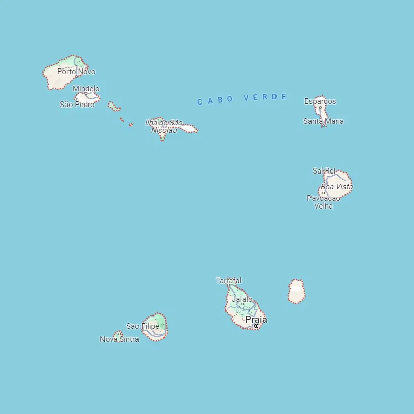
Google Maps: Cape Verde Map
Cabo Verde Islands
Cape Verde, officially known as the Republic of Cabo Verde, is an archipelago nation situated in the central Atlantic Ocean. This country is comprised of an array of 10 main islands and several smaller islets, all volcanic in origin. The archipelago is split into two groups: the Barlavento (windward) islands to the north and the Sotavento (leeward) islands to the south.
Barlavento Islands
Santo Antão
- Noted for its rugged terrain and verdant valleys, it is one of the most picturesque islands.
- Approximately 17.1° N, 25.1° W.
São Vicente
- Home to Mindelo, Cape Verde's cultural capital, celebrated for its music, vibrant nightlife, and annual Carnival.
- Approximately 16.8° N, 24.9° W.
Santa Luzia
- An uninhabited island with no permanent human settlements.
- Approximately 16.7° N, 24.7° W.
São Nicolau
- Features a landscape of mountains and fertile valleys.
- Approximately 16.6° N, 24.3° W.
Sal
- Renowned for salt flats, white sandy beaches, and as a hub for watersports.
- Approximately 16.7° N, 22.9° W.
Boa Vista
- Known for its long stretches of beach and dunes, it is also important for sea turtle nesting.
- Approximately 16.1° N, 22.8° W.
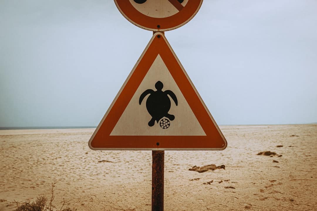
Photo by Katarzyna Urbanek
Sotavento Islands
Maio
- Quiet beaches and colonial-style architecture characterise this island.
- Approximately 15.2° N, 23.2° W.
Santiago
- The largest island, where the capital city Praia is located. It has a diverse landscape and a rich historical heritage.
- Approximately 14.9° N, 23.5° W.
Fogo
Dominated by Pico do Fogo volcano, the highest peak in Cape Verde which last erupted in 2014.Approximately 14.9° N, 24.5° W.
Brava
- The smallest inhabited island, is often referred to as the 'island of flowers.'
- Approximately 14.8° N, 24.7° W.
The additional smaller uninhabited islets include Ilhéus Secos or Ilhéus do Rombo, which are located near Brava and Fogo.
Cape Verde Map
The Cape Verde map below highlights the various airport routes and flight durations between the islands, as well as the time for the popular ferry crossing from Mindelo to Porto Novo. Such connectivity makes travelling between the diverse islands of Cape Verde convenient.
All the islands in Cape Verde boast airports, with the exception of Brava, Santa Luzia, and Santo Antão. Bestfly Cape Verde connects these airports.
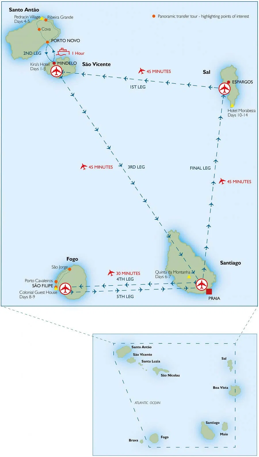
Cape Verde airports map from Maps-Cape-Verde.com
Cape Verde & Africa
Cape Verde lies around 570 kilometres (approximately 350 miles) west of the African mainland near Senegal and Mauritania. The archipelago encompasses a total area of about 4,033 square kilometres (1,557 square miles).
Historically, Cape Verde's strategic location along major Atlantic maritime routes made it an essential stopover for ships travelling between Europe, Africa, and the Americas. Today, the archipelago is known for its distinctive blend of Portuguese and African cultures, a legacy of its history of colonisation and trade. Recent estimates suggest Cape Verde has a population of around 550,000 people.
Despite its arid to semi-arid climate with minimal rainfall and variable temperatures, Cape Verde's generally mild weather and abundant sunshine make it a favoured spot for holidaymakers seeking beaches and cultural experiences. Additionally, Cape Verde boasts a stable democratic political system and is considered one of the most developed and democratically advanced countries in Africa.
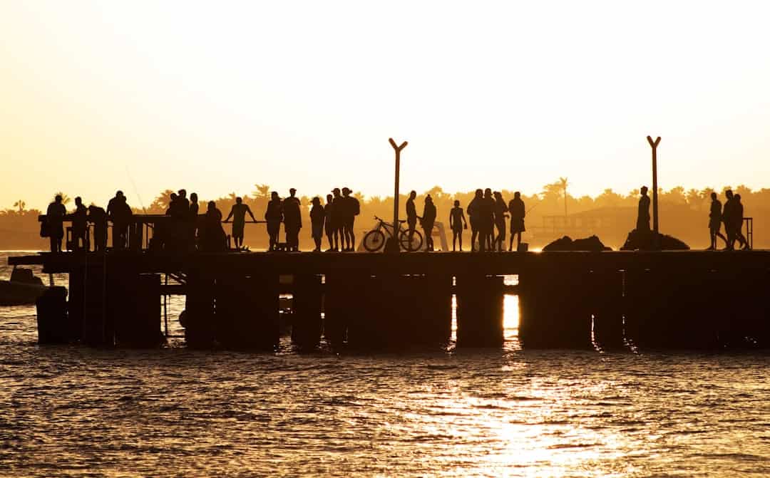
Photo by Álvaro Ibáñez
FAQ
Where is Cape Verde situated?
Cape Verde is an archipelago comprising 10 volcanic islands located off the west coast of Africa in the Atlantic Ocean.
What is the geographical location of Cape Verde?
Cape Verde is situated approximately 570 kilometres (350 miles) off the coast of Western Africa.
Which continent does Cape Verde belong to?
Cape Verde is part of the African continent.
In which ocean is Cape Verde located?
Cape Verde is located in the Atlantic Ocean.
How far is Cape Verde from Africa?
Cape Verde is located about 570 kilometres (350 miles) west of mainland Africa.
What are the coordinates of Cape Verde?
The coordinates of Cape Verde are approximately 16.5388° N latitude and 23.0418° W longitude.
Is Cape Verde closer to Europe or Africa?
Geographically, Cape Verde is closer to Africa than Europe.
Is Cape Verde considered part of West Africa?
Yes, Cape Verde is generally classified as part of West Africa.
How many islands are there in Cape Verde?
Cape Verde comprises 10 main islands, along with several smaller islets and rocks.
What are the names of the islands in Cape Verde?
The main islands of Cape Verde are Santiago, Santo Antão, São Vicente, São Nicolau, Sal, Boa Vista, Maio, Fogo, Brava, and Santa Luzia.
How can I travel to Cape Verde?
There are several ways to reach Cape Verde. The most common way is by air travel. Many international airlines operate flights to Cape Verde's main international airport, Amílcar Cabral International Airport (SID), located on the island of Sal. You can also fly to other airports such as Nelson Mandela International Airport (RAI) on Santiago Island or Cesária Évora Airport (VXE) on São Vicente Island. Additionally, there are ferry services available from neighbouring countries such as Senegal and Guinea-Bissau.
Are there direct flights to Cape Verde from my country?
Direct flights to Cape Verde from various countries are available, but the availability may vary depending on your location. It is recommended to check with airlines or travel agencies for specific flight options from your country.
Can I travel to Cape Verde by boat?
Yes, it is possible to travel to Cape Verde by boat. There are ferry services available from neighbouring countries, such as Senegal and Guinea-Bissau. However, it is important to note that the availability and schedules of these services may vary, so it is advisable to check with relevant authorities or local transportation providers for up-to-date information.
Are there any visa requirements for travelling to Cape Verde?
Yes, visitors to Cape Verde usually require a visa. However, the visa requirements may vary depending on your nationality. Some countries have visa exemption agreements with Cape Verde, allowing their citizens to enter without a visa for a specified period. It is recommended to check with the nearest Cape Verde embassy or consulate or consult official government websites for accurate and updated visa information.
How long does it take to travel to Cape Verde?
The duration of travel to Cape Verde depends on your location and the mode of transportation chosen. By air, the approximate flight times from Europe range between 4 to 7 hours, while flights from North America can take around 7 to 10 hours. Travel times by boat or ferry will vary depending on the departure point and route.
What is the best time to visit Cape Verde?
Cape Verde enjoys a pleasant climate throughout the year, so the best time to visit depends on your preferences and the activities you plan to engage in. The dry season, from November to June, is generally considered the most popular time for tourists due to warmer temperatures and less rainfall. However, some visitors also enjoy the slightly cooler temperatures and occasional rain showers during the wet season, from July to October.
Are there any travel restrictions or health requirements when visiting Cape Verde?
Travel restrictions and health requirements may vary depending on factors such as your country of origin and current global circumstances. It is advisable to review the latest travel advisories and guidelines provided by your government and international health organizations. Additionally, consulting with a healthcare professional regarding vaccinations or health precautions specific to Cape Verde is recommended before your trip.
Stay Informed While Traveling
Make sure to stay updated on the latest travel advice from the Foreign, Commonwealth & Development Office by visiting Travel Aware. This valuable resource offers information on various aspects of travel, such as safety and security, local laws, currency, and health considerations.
Additionally, Travel Aware provides a helpful Foreign Travel Checklist to ensure you have everything you need for your journey. Remember that travel advice can change frequently, so it's essential to check for updates regularly.
Want more?
Sign up to our newsletter